
Integrated Geotechnical, Environmental, and Site Development Considerations for a Multi-Storey Residential Development in Hinton, Alberta.

Abstract
1. INTRODUCTION
Residential developments in foothill and mountain-interface regions commonly present a more complex engineering environment than comparable projects on level urban parcels. In such settings, design feasibility is influenced not only by architectural programming and municipal servicing, but also by topography, subsurface variability, drainage pathways, slope geometry, climatic exposure, and regulatory constraints. Consequently, these projects require integrated evaluation of site planning, geotechnical conditions, environmental due diligence, infrastructure servicing, and long-term constructability.
Mountain View Hinton is a representative example of this development condition. The project is located near the intersection of Yellowhead Highway (HWY-16) and McArdell Drive in Hinton, Alberta, on a site influenced by irregular topography, ravine adjacency, and winter-weather exposure. The proposed development consists of a four-storey residential apartment building containing 43 dwelling units, together with underground parking, surface parking, bicycle storage, and landscaped amenity space. The site also benefits from access to existing municipal infrastructure and regional transportation connectivity.
The technical significance of the project arises from the need to address environmental due diligence, subsurface characterization, slope-related constraints, drainage control, and climate-responsive durability within a single development framework. Environmental investigations identified unknown fill requiring further assessment, while geotechnical investigation identified fill, sandstone, and silty sand strata through borehole drilling and field testing. These conditions directly influence excavation planning, foundation selection, retaining requirements, groundwater management, and long-term serviceability [2]. Alberta’s tiered remediation framework recognizes that site-specific conditions may require assessment beyond generic assumptions [1], while the Canadian Foundation Engineering Manual emphasizes the importance of investigation quality and groundwater characterization in reducing foundation and construction risk [2].
This paper presents Mountain View Hinton as a case study in integrated residential site engineering under Western Canadian conditions. The objective is to examine how environmental review, geotechnical investigation, ravine-edge considerations, drainage measures, and cold-climate and resilience-driven design responses can be synthesized into a practical engineering solution for a multi-storey residential development (Fig. 2).
2. PROJECT SETTING AND DEVELOPMENT PROGRAM
A. Site Location And Layout
The Mountain View Hinton development is located near the intersection of Yellowhead Highway (HWY-16) and McArdell Drive in Hinton, Alberta, on Lot 1, Block 14, Plan 8321567 (Fig. 1).

Fig. 1. Site location of the proposed Mountain View Hinton development near Yellowhead Highway and McArdell Drive, Hinton, Alberta
The parcel occupies approximately 40,510 sq. ft. and is planned for a four-storey residential apartment building containing 43 dwelling units (see Table 1 for details). The development program includes an underground parkade with 27 parking stalls, 28 surface parking stalls, bicycle storage facilities, and a landscaped amenity area oriented toward the rear ravine. The parcel benefits from direct access to a major regional transportation corridor and proximity to trails, parkland, and surrounding urban services, thereby enhancing both accessibility and development potential.
From a civil engineering perspective, the development arrangement is governed by both functional requirements and physical constraints. The parcel is characterized by irregular boundaries and variable topography, requiring the building footprint, internal circulation, and parking configuration to be planned with careful attention to grading transitions and land-use efficiency. The rear portion of the property interfaces with a natural ravine and adjacent low-lying terrain, introducing additional considerations related to slope setback, drainage routing, and the placement of retaining measures. As a result, the development configuration is more complex than that of a typical level urban parcel, since the final arrangement must balance architectural intent, vehicular access, municipal servicing, earthworks, and long-term stability within a constrained footprint.
The overall concept reflects an integrated planning approach in which building positioning, access geometry, and parking configuration are coordinated with the natural terrain. The inclusion of underground parking is particularly significant because it improves land-use efficiency and reduces surface congestion, thereby allowing a greater portion of the parcel to be allocated to circulation, landscaping, and amenity space. In addition, the project benefits from existing municipal infrastructure, including water supply, sewer and stormwater systems, and electrical service, which supports the feasibility of the proposed development. Because of the site’s connection to Highway 16, the design of site access and internal vehicle movement also required consideration of transportation approval requirements and safe ingress and egress control. Collectively, these factors establish the development layout as a technically driven response to both project objectives and physical site constraints.
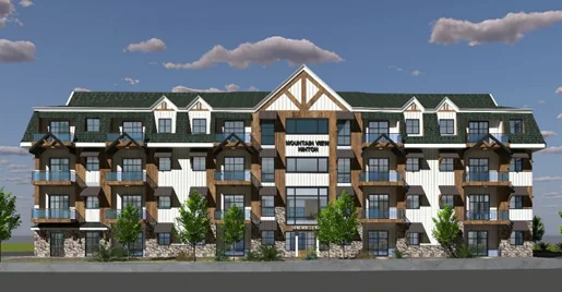
Fig. 2. Front elevation rendering of the proposed Mountain View Hinton development.
B. Site Constraints
The principal constraints affecting the Mountain View Hinton development arise from topography, subsurface variability, ravine adjacency, and climatic exposure. The parcel was initially undeveloped and characterized by irregular boundaries and variable ground-surface conditions. These features impose direct limitations on grading design, building placement, parking geometry, and construction staging. Unlike a level greenfield or urban infill site, the development envelope in this case must accommodate elevation transitions while maintaining adequate access, drainage performance, and compatibility with the intended residential land use.
A significant geotechnical and environmental constraint was the presence of unknown fill material identified during the initial environmental review. Fill of uncertain origin introduces risk because its composition, density, and engineering behavior may vary substantially across a site. From a geotechnical standpoint, uncontrolled or non-native fill may affect bearing performance, settlement response, excavation stability, and suitability for reuse as engineered fill [2]. From an environmental standpoint, such material may also require additional assessment to confirm compliance with applicable soil and groundwater criteria before development proceeds [1]. The need for Phase II environmental investigation and further subsurface assessment therefore reflected the importance of reducing uncertainty associated with these fill conditions [1], [2].
Another major constraint was the site’s interface with a natural ravine and adjacent low-lying terrain at the rear of the property. This condition imposed additional requirements related to slope stability, runoff control, erosion protection, and the long-term performance of retaining systems. Development near a ravine is not governed solely by foundation bearing considerations; it also requires evaluation of global and local stability, drainage pathways, and the potential effects of seepage or seasonal water movement on soil behavior [2]. As a result, the site layout and structural support strategy had to account for both the immediate building footprint and the surrounding ground response over time.
The climatic setting of Hinton introduced a further layer of constraint. The region is subject to severe winter conditions, including heavy snow loads, freezing temperatures, and exposure to hail and harsh weather. These factors influence not only building-envelope design, but also site grading, surface drainage performance, freeze-thaw durability, and maintenance requirements [2], [6]. In practical terms, the site must be designed to remain functional and serviceable under both normal operating conditions and seasonal climatic extremes. Accordingly, the constraints affecting the project are multidimensional and require a coordinated engineering response rather than isolated design solutions.
TABLE I PROJECT CHARACTERISTICS USED FOR CONCEPT DEVELOPMENT
|
Project Type |
Four-storey residential apartment |
|
Residential Units |
43 units |
|
Parking Program |
27 underground plus 28 surface |
|
Site Area |
40,510 sq ft (3,764 m2) |
|
Key Constraints |
Ravine edge, fill, grades, winter climate |
3. ENVIRONMENTAL AND GEOTECHNICAL BASIS
A. Environmental Review
A Phase I Environmental Site Assessment (ESA) was completed for the subject property at 140 McArdell Drive, Hinton, Alberta, in general accordance with CSA Z768-01 (reaffirmed 2022) and the Alberta Environmental Site Assessment Standard, December 2024 [3]. The Phase I ESA identified one Area of Potential Environmental Concern (APEC), namely unknown fill material within the subject site, with the associated Potential Contaminating Activity defined as importation of fill material of unknown quality [3]. On this basis, the Phase I ESA concluded that further investigation was warranted and recommended a Phase II ESA to assess potential impacts to soil and groundwater [3].
A Phase II ESA was subsequently undertaken in accordance with CSA Z769-00 (reaffirmed 2023) and the Alberta Environmental Site Assessment Standard, December 2024 [4]. The intrusive investigation included four boreholes, installation of groundwater monitoring wells in boreholes BH-2 to BH-4, and laboratory testing of soil and groundwater samples for petroleum hydrocarbons (PHCs), polycyclic aromatic hydrocarbons (PAHs), and volatile organic compounds (VOCs) [4]. Soil and groundwater analytical results were compared with the 2024 Alberta Tier 1 Soil and Groundwater Remediation Guidelines for residential/parkland use under coarse-grained criteria, and the reported results indicated that all analyzed parameters were below the applicable guideline values [4]. The Phase II ESA therefore concluded that no further subsurface environmental investigation was required at the time of reporting [4].
For residential developments of this type, the engineering significance of fill extends beyond demonstration of chemical compliance alone. Fill of uncertain origin may affect excavation management, material handling and reuse, groundwater interaction, drainage behavior, and the reliability of final grading works. Consequently, environmental due diligence should be closely coordinated with geotechnical assessment so that both regulatory and constructability considerations are addressed within a unified site-development framework [1], [4].
B. Subsurface Characterization
A geotechnical site investigation was undertaken to support foundation planning and assess the feasibility of the proposed multi-storey apartment development with underground parkade [5]. The field drilling program was carried out on June 24 and 25, 2025, and consisted of four boreholes, BH-1 to BH-4, drilled using solid stem augers. Boreholes BH-2 to BH-4 were advanced to 9.0 m below ground surface, while BH-1 was advanced to 6.0 m [5]. Grab samples were collected at regular depth intervals of approximately 0.75 m, and Standard Penetration Tests (SPTs) were conducted at 1.5 m intervals. In addition, three standpipe piezometers were installed in BH-2 to BH-4 to permit short-term groundwater monitoring [5].
The geotechnical report indicates that subsurface conditions generally consisted of sand and gravel fill underlain by sandstone and/or silty sand [5]. The near-surface fill layer was encountered in all boreholes and extended to depths ranging approximately from 3.2 m to 7.0 m, below which sandstone was encountered in some boreholes and silty sand in others [5]. Laboratory testing included natural moisture content determination, water-soluble sulphate testing on selected samples, and grain-size analyses [5]. The report emphasizes that soil conditions are geologically variable and may differ between borehole locations, and therefore that actual conditions should be confirmed during construction, particularly in areas of excavation [5].
In practice, subsurface characterization of this type is fundamental because it provides the technical basis for evaluating excavation behavior, bearing response, settlement potential, groundwater control requirements, and the suitability of below-grade construction such as an underground parkade [2], [5]. As emphasized in the Canadian Foundation Engineering Manual, the reliability of foundation recommendations depends directly on the adequacy of site investigation, the interpretation of subsurface variability, and the characterization of groundwater conditions [2].

Fig. 3. Approximate borehole layout and site exploration context.
4. DESIGN CONSTRAINTS AND ENGINEERING RESPONSE
A. Ravine Interface and Drainage
A principal engineering constraint associated with the Mountain View Hinton development was the ravine-adjacent condition located at the rear of the site (Figs. 3 and 4). For developments situated near sloping ground, satisfactory performance is governed not only by the bearing resistance of the foundation materials beneath the structure, but also by the stability of the adjacent soil mass, the prevailing groundwater regime, and the influence of surface runoff and erosion processes. In such settings, the design problem extends beyond local foundation support and must consider global slope stability, seepage conditions, and long-term serviceability of both the building platform and the surrounding terrain [2].
Project reports indicate that the development incorporated retaining measures and drainage controls in response to these site conditions. The project article describes mechanically stabilized earth (MSE) retaining walls, concrete retaining elements, and controlled drainage systems at the ravine interface, while the geotechnical report includes recommendations for subsurface drainage, lateral earth pressure, basement development, and excavation-related groundwater control [5]. This response is consistent with established geotechnical practice because retaining structures perform more reliably when structural restraint and hydraulic control are addressed concurrently [2]. In practical terms, the performance of an earth-retaining system depends not only on its ability to resist lateral earth pressures, but also on its capacity to limit hydrostatic pressure buildup behind the wall. Accordingly, the use of free-draining backfill, subdrainage, surface collection systems, and controlled discharge points is essential for maintaining long-term wall stability, reducing deformation, and preserving the overall stability of the retained ground [2], [5].
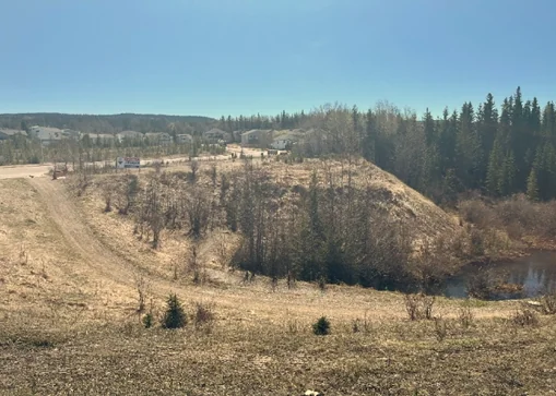
Fig. 4. Rear site condition showing slope transition toward the ravine and adjacent low-lying area.
This approach is consistent with conventional limit equilibrium analysis, in which slope stability is assessed by comparing resisting and driving forces along a potential failure surface [2]. Even where a retaining wall remains structurally adequate, inadequate drainage may increase groundwater pressures, reduce effective stress, diminish available shear strength, and lower the factor of safety of the surrounding slope system [2]. The ravine interface therefore required a composite stabilization strategy in which retaining measures, grading control, and drainage management were integrated to support both immediate constructability and long-term site performance.
B. Unknown Fill and Layout Optimization
A second major constraint was the presence of unknown or non-native fill identified during the environmental and subsurface review. The Phase I ESA identified one Area of Potential Environmental Concern (APEC), namely unknown fill material within the subject site, and recommended further investigation [3]. The subsequent Phase II ESA confirmed that the intrusive investigation was directed specifically at this fill-related concern through borehole drilling, groundwater monitoring, and laboratory assessment of soil and groundwater samples [4]. Fill of uncertain origin presents a significant challenge in both geotechnical and environmental terms because its composition, density, placement history, and engineering behavior are commonly variable. From a geotechnical perspective, uncontrolled fill may exhibit inconsistent stiffness, nonuniform drainage behavior, unpredictable settlement characteristics, and variable bearing response [2]. Where such material includes construction debris or poorly compacted zones, the potential for differential settlement increases, particularly beneath pavements, shallow foundations, slabs-on-grade, and retaining structures [2].
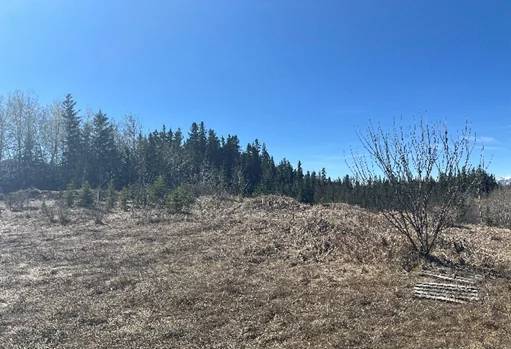
Fig. 5. Existing site conditions illustrated uneven surface grades and areas of apparent fill.
The engineering implications of fill extend beyond mechanical performance. Alberta’s Tier 2 contaminated-site framework recognizes that site-specific conditions, including fill characteristics, groundwater pathways, and land-use sensitivity, may necessitate a level of technical assessment beyond that provided by generic assumptions [1]. In practice, the presence of fill may influence excavation management, material classification, reuse potential, groundwater interaction, and confidence in the final grading platform. For residential developments, where serviceability requirements and long-term performance expectations are relatively demanding, it is necessary to evaluate both the chemical suitability and the mechanical acceptability of such materials [1], [2]. The site therefore required coordinated environmental and geotechnical interpretation rather than separate assessment of regulatory compliance and foundation support conditions.
This coordinated interpretation is reflected in the project reports. The Phase II ESA described near-surface sand and gravel fill and concluded that PHCs, PAHs, and VOCs in both soil and groundwater were below the applicable 2024 Alberta Tier 1 residential/parkland coarse-grained criteria, with no further subsurface environmental investigation recommended at that time [4]. The geotechnical report likewise identified sand and gravel fill across all boreholes and advised that fill thickness may vary significantly across the site, such that additional test pits or hand-augered holes may be required for more accurate stripping-volume determination and that footing support should extend below the fill layer [5]. Taken together, these findings indicate that the fill condition was both an environmental due-diligence issue and a geotechnical design issue.
Rather than treating the fill solely as a construction impediment, the project incorporated the excavation requirement into a broader site-optimization strategy by transitioning from a surface-parking-dominated concept to one that included an underground parkade. This response is technically rational because the need to remove or manage unsuitable near-surface materials may be used to create permanent below-grade functional space, thereby improving development efficiency. From a site-planning and engineering standpoint, the underground parkade offers several advantages: it reduces the portion of the site occupied by surface parking, permits more efficient use of the parcel for circulation and amenity purposes, and integrates excavation-related works into the permanent development scheme. It also allows closer coordination among the structural, geotechnical, and construction teams with respect to excavation depth, support requirements, groundwater control, dewatering, and retained-earth design [2], [5].
This response is consistent with the broader guidance of the Canadian Foundation Engineering Manual, which emphasizes that site investigation results should inform not only foundation selection, but also excavation planning, groundwater management, retaining systems, and constructability [2]. In this sense, the final layout represents a design adaptation in which a subsurface constraint was converted into a development advantage through coordinated engineering decision-making.
C. Cold-Climate Durability and Fire-Resilient Response
The climatic setting of Hinton imposed a significant design constraint affecting both structural performance and long-term envelope durability. The region is subject to prolonged freezing temperatures, seasonal snow accumulation, freeze-thaw cycling, hail exposure, and severe weather, all of which influence roof behavior, moisture migration, thermal performance, and maintenance demand. Accordingly, the building response should be understood as part of an integrated engineering strategy intended to address durability, occupant safety, and life-cycle performance.
From a structural and enclosure-performance perspective, the adoption of a steep roof profile is consistent with cold-region design practice because roof geometry governs snow retention, snow shedding, localized drift formation, and drainage behavior during melt periods. A steeper roof slope may reduce the duration of snow retention and improve runoff during thaw cycles, thereby limiting the risk of ice accumulation and localized ponding. The building envelope strategy is similarly important. Triple-pane glazing and a high-performance wall assembly improve effective thermal resistance and reduce conductive heat loss through the enclosure. In building-science terms, these measures improve hygrothermal performance by limiting cold-surface conditions that may lead to interstitial or interior-surface condensation. National Research Council Canada guidance and the National Building Code of Canada identify heat transfer, air leakage, and condensation control as fundamental aspects of compliant and durable wall-system performance [6].
The use of durable exterior cladding is also technically significant in a mountain-influenced environment. Repeated freeze-thaw cycles, wind-driven precipitation, hail, and thermal movement place sustained demand on the building exterior. Where cladding is supported by appropriate flashings, drainage layers, and drained or ventilated cavity detailing, the wall assembly is better able to resist water ingress, accommodate drying, and preserve the integrity of structural and insulation components [6]. This is important not only for thermal efficiency, but also for long-term serviceability, since envelope deterioration in multi-storey residential construction may lead to moisture damage, reduced insulation effectiveness, and increased maintenance demand. NRC guidance further emphasizes that wall-system performance is closely linked to thermal resistance, airtightness, and condensation resistance [6].
The use of non-combustible exterior materials may also be justified as a resilience-oriented design measure for a project located within a region that is seasonally exposed to wildfire risk. In this context, the selection of non-combustible cladding and related exterior components may reduce ignition susceptibility and improve the robustness of the building envelope under external fire exposure. However, in the absence of a project-specific wildfire hazard assessment, local bylaw requirement, or authority-mandated fire-resilience criterion, this rationale is best presented as a resilience consideration supplementary to the primary cold-climate and durability objectives of the envelope design.
The cold-climate response also extends to the site and lower envelope. Freeze-thaw action may affect entrance slabs, paved areas, shallow drainage infrastructure, and the seasonal response of near-surface fill materials [2], [6]. Consequently, grading and drainage must be configured to minimize ponding, control infiltration near the foundation, and maintain positive runoff under both thaw events and rainfall conditions. Considered collectively, the selected roof form, glazing system, cladding durability, thermal envelope, and non-combustible exterior materials (Fig. 6) represent a unified durability strategy in which thermal control, moisture management, and environmental exposure resistance are treated as interdependent engineering objectives [2], [6].
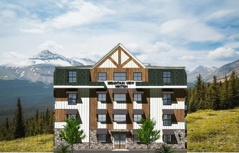
Fig. 6. Climate-responsive architectural rendering.
5. DISCUSSION
This case study highlights the value of integrating environmental and geotechnical investigations early in the design process. Once unknown fill was identified during the environmental review, the project required evaluation of both chemical suitability and geotechnical constructability rather than separate treatment of these issues [1], [3], [4]. That integrated approach provided a stronger basis for grading decisions, excavation planning, material management, and coordination between subsurface conditions and the final development layout [2], [4], [5].
The project also demonstrates the importance of designing for both immediate stability and long-term serviceability. In this case, retaining measures, drainage systems, parking configuration, and building-envelope decisions all contributed to the overall performance of the proposed development [2], [5], [6]. For sites in foothill and mountain-interface settings such as Hinton, technical success depends on recognizing that subsurface conditions, slope constraints, climatic exposure, and access requirements are interdependent rather than isolated design variables. The engineering significance of the project therefore lies not in any single design feature, but in the coordinated response developed across environmental, geotechnical, civil, and building-envelope considerations.
6. CONCLUSION
Mountain View Hinton represents a practical case study in integrated civil engineering for residential development on a constrained site. The project required coordinated assessment of environmental conditions, subsurface variability, ravine-edge stability, drainage control, access planning, and cold-climate durability in support of a multi-storey residential building with underground parking [3]–[6]. The case demonstrates that technical risks associated with unknown fill, topographic relief, groundwater-related constraints, and severe climatic exposure can be managed more effectively when site investigation findings are incorporated into planning and design from the outset [1], [2].
More broadly, the project illustrates that successful development on complex sites depends on early integration of environmental due diligence, borehole-based subsurface characterization, retaining and drainage strategies, and durability-oriented building response. This integrated approach improves constructability, supports regulatory and technical decision-making, and provides a more reliable basis for long-term serviceability of the completed development.
DATA AVAILABILITY STATEMENT
Some data that support the findings of this study are contained within project-specific environmental and geotechnical reports cited in this paper. Additional project information is proprietary or confidential in nature and may only be provided with restrictions. Requests for non-public supporting materials may be directed to the corresponding author and will be considered subject to client and project-permission requirements.
ACKNOWLEDGMENT
The authors gratefully acknowledge Md Altaf Hossain, P.Eng., M.Sc. Environmental Engineering, Project Engineer, MR Engineering Ltd. (altaf.hossain@mrengineering.ca), and his Geotechnical and Environmental team for their contributions to the field investigation program, drilling supervision, and laboratory assessment related to this project. The authors also acknowledge the project team for providing non-public project summaries and visual materials used for case-study presentation. Project visuals are included for illustrative purposes only and are not treated as primary technical references.
Note: Figures derived from project visuals are included for illustrative support of the case study and are not used as primary technical sources.
REFERENCES
[1] Alberta Environment and Parks, Alberta Tier 2 Soil and Groundwater Remediation Guidelines, Edmonton, AB, Canada, 2022.
[2] Canadian Geotechnical Society, Canadian Foundation Engineering Manual, 5th ed., Surrey, BC, Canada, 2023.
[3] MR Engineering Ltd., Environmental Site Assessment Phase I, 140 McArdell Drive, Hinton, Alberta, Project No. ESA-2025-021, prepared for ACI Homes Inc., Edmonton, AB, Canada, Aug. 14, 2025.
[4] MR Engineering Ltd., Environmental Site Assessment Phase II, 140 McArdell Drive, Hinton, Alberta, Project No. ESA-2025-032, prepared for ACI Homes Inc., Edmonton, AB, Canada, Aug. 23, 2025.
[5] MR Engineering Ltd., Geotechnical Site Investigation: Proposed Development for Multi-Storey Apartment Building at 140 McArdell Drive, Hinton, Alberta, Project No. GEO-2025-028, prepared for ACI Homes Inc., Edmonton, AB, Canada, Sep. 18, 2025.
[6] National Research Council Canada, National Building Code of Canada 2020, Ottawa, ON, Canada, 2022.
Comments 0
No comments yet. Be the first to comment!
Sign in to leave a comment.